Tracking storms Karen and Lorenzo
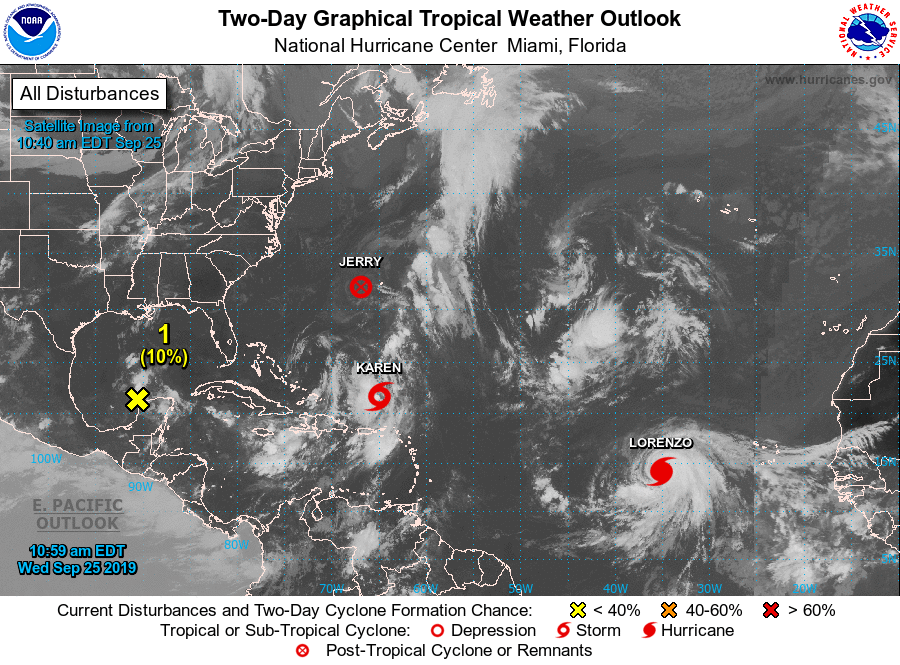
The tropics are heating up. Tropical storms Karen and Lorenzo are churning in the Atlantic, and sub-tropical cyclone Jerry continues its treck east.
It’s uncertain whether Karen will strike the U.S. or not, but Puerto Rico experienced heavy rains and wind from the storm Sept. 24.
According to the National Hurricane Center, Karen, with sustained top winds of 40 miles per hour, is expected to pass near or over Puerto Rico and the Virgin Islands Tuesday morning
Puerto Rico is still recovering from the damage of hurricanes Irma and Maria, and this tropical storm could cause massive flooding with a direct hit.
So far, Karen is the only tropical storm, Fla. needs to worry about. Right now, many parts of the state are in the clear, but residents should be cautious of heavy rain and winds if the storm makes a westerly turn, with South Fla. in its path.
Tropical storm Lorenzo formed off the coast of Africa on Monday.
“Tropical Storm Lorenzo had 65 mph winds early Tuesday and has the potential to become a major hurricane with winds up to 120 mph later this week,” the National Hurricane Center said on their website.
Tropical storm Lorenzo is not going to be a threat to the U.S., but it will cause heavy surf in the mid-Atlantic.